Virtual reality rainforest buffer audit
There are some areas of East Gippsland and the Central Highlands which have higher resolution within Google Earth, where individual trees can be seen. Clearfell logging and rainforest stands can be made out in these areas.
By using the ruler/measure function (Tools->Ruler) in Google Earth, and setting it to metres, you can measure the rainforest buffer width (the amount of forest between the edge of logging and the rainforest).
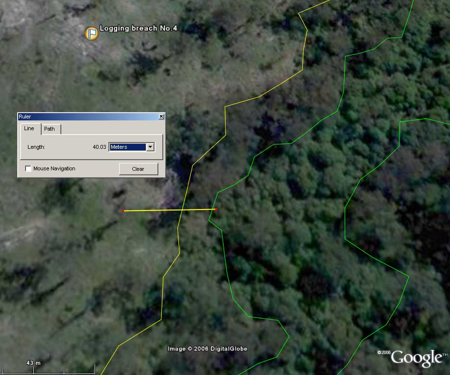
Example of using the ruler function in Google Earth to see if rainforest buffers comply to the Code of Forest Practices. VRN has added a green line to mark the warm temperate rainforest and a yellow line to mark where clearfell logging has occurred.
As at October 2006, only a limited amount of East Victorian forest has higher resolution images in Google Earth.
!!! VRN found five instances where logging appears to be too close to rainforest stands, in breach of the 1996 Code of Forest Practices for Timber Production. Four alleged breaches are in East Gippsland and the fifth is in the Central Highlands.
All rainforest stands should get a minimum 40 metre buffer according to section 2.3.7(i) of the Code of Forest Practices for Timber Production. See more about the politics of rainforest buffers.
Breach No.5 in the Central Highlands should have a 60 metre buffer due to the fact the rainforest is Myrtle beech (Nothofagus) dominated. See section 2.3.7(ii) of the Code of Forest Practices for Timber Production.
Download alleged buffer breaches ![]() . (VRN has marked these up with green lines for rainforest and yellow lines for clearfell logging to aid in measurement).
. (VRN has marked these up with green lines for rainforest and yellow lines for clearfell logging to aid in measurement).
Note:
- VRN assumes Google Earth imagery be fairly accurate however these alleged breaches still need to be field checked to determine accuracy.
- VRN does not endorse the current minimum rainforest buffer standards in the Code of Forest Practices. VRN has the view rainforest buffers should be much wider.
- VRN has create this virtual reality rainforest buffer audit for educational and discussion/debate purposes to highlight issues surrounding current rainforest protection from logging.
- If VicForests or the native forest logging industry spokespeople wish to challenge the claims made by VRN then they can click here to get our contact details.
- In fairness, VRN has marked up some rainforest buffer areas where logging has complied to the Code of Forest Practices for Timber Production.
- VRN has taken care to align these images as accurately as possible however there may be some misalignment in some places. Feel free to make adjustments.